Regulations and Anchor Tools
Regulations
The list of rules and regulations are not exhaustive and will be progressively updated. The objective is to help captains as much as possible but the authors will not take responsibility in case of new changes, misunderstanding of the local regulations.
Please refer to official legal sources available for each country.
CROATIA

ARGUS AnchorTag - National Park Kornati
-
National Park Kornati
The Kornati archipelago of Croatia, also known as the Stomorski islands, is located in the northern part of Dalmatia, south from Zadar and west from Šibenik, in the Šibenik-Knin County. With 35 kilometres (22 miles) length and 89 islands, some large, some small, in a sea area of about 320 square kilometres (124 sq mi), the Kornati are the densest archipelago in the Mediterranean Sea. From northwest to southeast (from the island of Balabra to Samograd), and from northeast to southwest (from Gangarol to Mana) they stretch for 13 km (8 miles). The name of the archipelago is the plural form of the name of the largest island, called Kornat.
You’ll need a valid ticket to sail through the National Park. Check out Price list for 2023.
Visit the website and the Buoys locations
-
Besides the international commitments and directives, including the prohibition of anchoring of the Nature Protection Act, Croatia has some regulations for the protection of Posidonia oceanica and its habitat:
-Zakon o zaštiti prirode NN 80/13
–Pravilnik o strogo zaštićenim vrstama NN 144/2013(Ordinance on Strictly Protected Species OG 144/2013)
–Pravilnik o strogo zaštićenim vrstama NN73/2016(Ordinance on Strictly Protected Species OG 73/2016)
-Zakon o zaštiti prirode NN15/2018. Article 153 (OG 15/18):
(1) Deliberate picking, cutting, felling, excavation, collection or destruction of individuals of strictly protected plants, fungi, lichens and algae from nature in their natural area of distribution is prohibited.
(2) The following actions with strictly protected animals from nature in their natural area of distribution are prohibited:All forms of deliberate capture or killing
Deliberate harassment, especially during breeding, rearing, hibernation and migration.Deliberate destruction or taking of eggs and their storage, even if empty.
Intentional destruction, damage or removal of their developmental forms, nests or litters.
Damage or destruction of their breeding or resting areas.
(3) It is prohibited to keep, transport, sell, exchange and offer for sale or exchange live or dead individuals from the nature of strictly protected species referred to in paragraphs 1 and 2 of this Article, and in the case of birds, the said prohibitions also apply to any easily recognizable part or derivative thereof.
–Zakon o zaštiti prirode NN14/2019
–Zakon o zaštiti prirode NN127/2019
-In the Ordinance on the list of habitat types and habitat map OG 27/21 “Pravilnik o popisu stanišnih tipova i karti staništa NN 27/21”, The Habitat type Posidonia beds is included in Annex II, List of endangered and/or rare habitat types of national and European significance present on the territory of the Republic of Croatia and in the Annex III, List of natural habitat types of the European Union interest present on the territory of the Republic of Croatia. September 2021 Document No. 20144905/13206 32.
FRANCE
-
Marine safety, security and environmental protection are in charge of the maritime prefect in France.
The pressure of tourism, especially during the high season, the continuous increase of yacht sizes and the rapid degradation of the Posidonia meadows are the main elements that have led the French Maritime Prefect to develop new policy to further organize anchorages along the Mediterranean coastline. The aim is to balance the various interests, both public and private, by taking into account the economic weight of the yachting industry whilst protecting marine habitats.
Different decrees have been adopted. Each of these decrees have run through public consultation processes. The contributions and remarks that have been made have been systematically studied. Please find more information on the responses provided to all actors here.
In summary:
1.- Decree No. 123/2019 of June 03, 2019 sets the general framework for anchoring and stopping of vessels in the French territorial waters of the Mediterranean Sea.
2.- Decree No. 155/2016 of June 24, 2016 organizes the anchoring of large vessels (over 45 meters). It creates anchoring areas for these vessels and an authorization or declaration regime.
3.- Local decrees decline the 123/2019 decree by establishing a coherent system of anchoring and stopping areas along the coastline for vessels from 24 meters (20 meters on the sectors that justified it).
The territorial decrees result from a large and collective process initiated in 2018 based on consultation with different stakeholders.
-
DescrFor yachts >45m:
Decree No. :Decree No 025/2023 of February 24, 2023
Decree No: Decree No 36/2023 of March 8, 2023
Decree No. 123/2019 of June 03, 2019: gives the general framework
Territorial decrees
Department
Zone
Number
06
From the mouth of the Var river to the limits of the French, Monegasque and Italian territorial waters
06
From the pointe de l’Aiguille to the mouth of the Var river
vessels of 20 meters and over
vessels of 24 meters and over
06/83
From the old port of Saint-Raphaël to the pointe de l’Aiguille
83
From the Cap Pinet to the pointe de Saint Aygulf
83
From the Cap Bénat to the pointe lof the Bonne Terrasse
83
From the Cap Carqueiranne to the Cap Bénat
83
From the pointe Fauconnière to the cap Cépet
/13
Perimeter of the La Ciotat bay
13
Perimeter of the Calanques National Park
13
Perimeter of the N2000 site « côte bleue marine »
34
Off the coast of the Hérault department
66
Off the coast of the Pyrénées-Orientales department
2A
Perimeter of the Bouches de Bonifacio reserve
2A
Perimeter of Belgodère to Roccapina
2B
Perimeter of the Natural Marine Park of the Cap Corse
2B
Perimeter of Bastia to Porto-Vecchio
(If any doubt, anchor more than 30 m deep in the french Riviera and 40 m in Corsica (limit of the presence of Posidonia oceanica)
Database
Official source for maps: https://data.shom.fr
Regulations and Posidonia also available on the free App DONIAiption text goes here

ARGUS AnchorTag - Sud France - Territorial decrees
-
The Maritime Prefect leads and coordinates the action of the administrations at sea and the implementation of their resources. It is under his coordination that the anchorage control policy will be implemented. This policy will be smart and take into account local situations. The Prefecture Maritime has full confidence in the sense of responsibility of French and foreign captains. Nevertheless, bad faith and abuses will be systematically dealt rigorously and firmly.
Sanctions can be up to 150 000 euros fine, 3 years prison and the ban to navigate in the French territorial waters.
-
WHERE CAN I FIND MORE INFORMATION REGARDING THE NEW FRENCH ANCHORING REGULATIONS AND POSIDONIA?To find out more information about the new French anchoring regulations and Posidonia, please consult official sources such as: https://data.shom.fr and https://www.premar-mediterranee.gouv.fr/
WHAT ARE THE LEGAL CONSEQUENCES FOR BREAKING THE LAWS ON POSIDONIA?The Maritime Prefect leads and coordinates the action of the administrations at sea and the implementation of their resources. It is under his coordination that the anchorage control policy will be implemented. This policy will be smart and take into account local situations. . The Prefecture Maritime has full confidence in the sense of responsibility of French and foreign captains.. Nevertheless, bad faith and abuses will be systematically dealt rigorously and firmly.
Sanctions can be up to 150 000 euros fine, 3 years prison and the ban to navigate in the French territorial waters.WHERE ARE THE POSIDONIA AREAS IN FRANCE?Posidonia is present in waters between 0 and 30- 40 metres in depth.
You can find out where the Posidonia areas are by visiting www.donia.fr or by using the free DONIA app. DONIA is a free app to help access to maps of the seabed and up-to-date regulations for a serene anchorage.If any doubt, anchor more than 30 m deep in the french Riviera and 40 m in Corsica (limit of the presence of Posidonia oceanica)
More generaly, aim for sandy areas, easily identifiable by their clear bottom. Use appropriate length of chain and warp. Raise your anchor correctly (once the boat is in position).WHY IS THERE A NEED TO PROTECT POSIDONIA?Posidonia is known as “the lung of the Mediterranean” for being one of the most important sources of oxygen in the Mediterranean Sea. It is a refuge and breeding place for more than 400 plant species and 1,000 animal species. Its economical value is higher than that of coral reefs! It is also highly vulnerable – it grows just 1 metre per century and it cannot be restored.
WHAT IS POSIDONIA?
Posidonia oceanica is a marine plant, endemic to the Mediterranean Sea. It lives between 0- and 40-meters depth. It is highly protected and is the KEY habitat for the Med Sea. Its economical value is higher than that of coral reefs! The growth is really slow, and once destroyed we can not restore it.WHY DO THE RESTRICTIONS ONLY APPLY TO THE SOUTHERN END OF PAMPELONE BEACH?On the Pampelonne beach is planned in a short term an eco-mooring project dedicated to yachting. It will enable to both offer a safe solution for captains and protect the Posidonia Habitat.
More info here : https://www.ramatuelle.fr/projet-de-zone-de-mouillage-dequipements-legers-zmel/HAS ANYONE THOUGHT OF OFFERING UP THE SOLUTION OF LAYING MOORING FIELDS?
Eco mooring projects are under development in France to offer a short term solution to yachts in areas covered by Posidonia habitat with no sandy areas.
However, this type of project is complex in terms of environmental, technical and economical issues, and requires some time to offer a safe and eco-friendly mooring to captains. French authorities are accelerating their implementation to be complementary with the new regulations.Bonifacio and Pampelonne should be the first projects to be set up. Others should follow.
WHY IS IT ONLY VESSELS OVER 24M THAT THE RULES APPLY TO?
24 m is the threshold used to differentiate professional and non-professional vessels in the French legislation.
There are indeed many more vessels under 24 m (the average is around 10 m around). However, the impact of small units is less important. They destroy mainly leaves, and do not impact the dead meadows.
For more information on the impact of anchoring of yachting you can watch this video: Andromède Océanologie Video
However, the repetition of anchoring of small units can also have some impact on the long term on the dead meadows. Some Posidonia areas are banned from anchoring for all type of units and many eco-mooring projects are under development.
WILL THE MOORING AREAS BE NEAR THE COASTLINE SO IT IS POSSIBLE TO ENJOY THE LANDSCAPE?
Bonifacio and pampelonne should be the first areas where eco moorings will be set up and other projects will follow.
It is still possible to enjoy the French coast. Anchoring is not forbidden everywhere but only in the posidonia habitats for boats above 24 m length.
-
Andromede Oceanologie and AERMC have developed a free app to help access to maps of the seabed and up-to-date regulations for a serene anchorage.
It is intended for yachtsmen, divers, fishermen and all sea lovers who wish to benefit from accurate maps, enriched with data on marine life and real-time information on surface activities.
DONIA works and raises awareness of environmental preservation by providing extremely accurate maps of the nature of the seabed, enabling Mediterranean yachtsmen to anchor outside the protected Posidonia meadows.!
To access the ARGUS AnchorTag App please click here.
GREECE
-
Gyaros MPA
15 eco-moorings around Gyaros MPA (Aegean Sea, Greece) to regulate and mitigate anchoring pressure on Posidonia and coralligenous seabeds within the frame of the CYCLADES LIFE Project.
For more information about the CYCLADES LIFE Project please click here.
-
DONIA APP
Andromede Oceanologie and AERMC have developed a free app to help access to maps of the seabed and up-to-date regulations for a serene anchorage.
It is intended for yachtsmen, divers, fishermen and all sea lovers who wish to benefit from accurate maps, enriched with data on marine life and real-time information on surface activities.
DONIA works and raises awareness of environmental preservation by providing extremely accurate maps of the nature of the seabed, enabling Mediterranean yachtsmen to anchor outside the protected Posidonia meadows.
-
Beside the international commitments and directives listed above, Greece has passed the following national laws concerning the protection of Posidonia oceanica. None of them is specific for safeguarding the meadows from anchoring.
-Law n° 3937/2011 (Official Journal 60/A/2011, art. 9) on Biodiversity Conservation The establishment and operation of fish farm units over Posidonia meadows are prohibited within Natura 2000 sites.
-Decision 31722/2011 (Official Journal 2505/B/2011) Framework of Spatial Planning and Sustainable Development for aquaculture. The establishment and operation of any aquaculture units over Posidonia meadows are prohibited within Natura 2000 sites.
-Decision 167378/2007 (Official Journal 241/D/2007) Implementation of Council Regulation (EC) No 1967/2006 (concerning management measures for the sustainable exploitation of fishery resources in the Mediterranean Sea). Definition of marine areas with Posidonia oceanica meadows within the Natura 2000 network where fishing with towed gears is prohibited.
-Decision 2886/14244/2019 (Official Journal 241/D/2007) Definition of additional marine areas with Posidonia oceanica meadows outside the Natura 2000 network where fishing with towed gears is prohibited.
-Joint Ministerial Decision 33318/3028 (Official Journal 1289/1998) Definition of measures and processes for the conservation of natural habitats and of wild flora and fauna, with reference to Posidonia.
-Law 4607 (Official Journal 65/A/2019) Amendment of Law 2971/2001 on the use of seashore that also defines the required process for the issuance of permits and for the installation of moorings.
-Decision 4065/330700 (Official Journal 6/B/2020)Amendment of Decision 6719/146097/29.12.2016 of the Minister of Agricultural Development and Foods «Establishment of management plan for the fishery gear “winch trawls” for fishing Spicara smaris and Boops boops in particular areas in Greek waters» (Β 4348).
-Decision 28990/358 (Official Journal 181/D/2019) Approval of the amendment of the Regional Spatial Plan of the North Aegean Region and environmental approval of the plan.
-Decision 142569 (Official Journal 4728/B/2017) Programmatic measures for achieving or sustaining favorable conservation status of marine waters, based on paragraph 9 article 12 of Law 3983/2011 (Α’ 144).
-Decision 126635 (Official Journal 3799/B/2016) Approval of monitoring programs for the continuous assessment of the environmental status of marine waters, based on article 11 of Law 3983/2011 (Α’ 144).
-Decision 1175 (Official Journal 2939/B/2012) Approval of environmental targets and indices for marine waters, based on paragraph 3 article 10 of Law 3983/2011 (Α’ 144)
ITALY
-
National
Italian Marine Protected Areas and the management of the Natura 2000.
Regulation implementing Directive 92/43/EEC on the conservation of natural and semi-natural habitats, as well as wild flora and fauna.
Regional
Site specific conservation measures for Ligurian marine SCIs.
Link 1 | Link 2Safeguard measures for habitats referred to in Annex I of Directive 92/43/EEC pursuant to L.R. 28/2009
Proposal for a resolution on the regulation of recreational nautical anchoring on SAC in Posidonia following the 2018.
Rules for the enforcement and organization of the protected area named Portofino.
Product T2.2.7a Analysis of feasibility and proposal for a joint regulation on recreational boating and anchoring and mooring activities Portofino Marine Protected Area: Compatibility assessments with other regulations in force.
-
Portofino Marine Protected Area (MPA)
The Portofino MPA extends to the municipalities of Camogli, Portofino and S. Margherita Ligure. There are a total of 5 mooring fields with up to 107 buoys for boats between 7.5m and 24m length.
For more information & reservations please visit the website http://www.portofinoamp.it/
For information on the Rules for the Enforcement and Organization of the MPA please click here.
To contact the Administrative office call +39 0185.287247 or email info@portofinoamp.it
MONACO
-
National
Article 0 & o.244-14in the “Code of the Sea” states: “Fishing with bottom trawls, seines and similar nets towed over Posidonia or other marine phanerogams meadows is prohibited.”
SPAIN
-
National
Andalucía
Catalonia
Order 91.210.098 (DOGC no. 1479, page 4395, dated 8/12/1991), where all species of marine phanerogams present on the coast are declared protected
Valencia
Order of January 23, 1992 to regulate activities on seagrass meadows.
Balearic Islands
PRUG (Master Plan for Use and Management, published in the BOIB No. 196 of 31)
Decree 25/2018 of July 27, on the conservation of Posidonia oceanica in the Balearic Islands
Mallorca
Law 2/2017, of June 27, declaring the Es Trenc- Maritime-Terrestrial Natural Park
Salobrar de Campos SCI ES0000083 management plan (northern section).Decree 49/2015, of May 22, approving the Natura 2000 Management Plan of the Serra de Tramuntana.
Decree 36/2007, of March 30, approving the Management Plan of the Place of Community Importance (SCI) Costa de Levante de Mallorca (ES5310030)
Menorca
Ibiza and Formentera
Decree 38/2007, of March 30, 2007, approving the Plan of Management of the Place of Community Importance (LIC) Tagomago (ES0000082).
ZEC 0000084 Ses Salines de Ibiza and Formentera – Decree 48/2015, of 22 de May, which approves the Natura 2000 Management Plan for the Salinas de Ibiza
and Formentera The natural park of Las Salinas, includes different anchoring areas that are
described in the regulations (Decree 132/2005, of December 23, which establishes
approves the Master Plan for the Use and Management of the Ses Salines Natural Park
d’Eivissa i Formentera, article 117).
-
Balearics Islands Mooring fields
There are 9 eco-mooring fields around the Balearic coast:
Mallorca: Cala Blava & Sa Dragonera/Sant Elm
Menorca: Illa den Colom & Cala Fornells
Ibiza: Ses Salines
Formentera: Espalmador & Es Calò des Oli
How to book? Click hereBookings can be made through the website Port IB
Monday to Friday, 9:00 am – 2:00 pm, call 971 74 56 25
Monday to Friday, 2:00 pm – 7:00 pm, call 673 03 96 23
Saturday, Sunday and bank holidays, 9:00 am – 7:00 pm, call 673 03 96 23For booking on the same day please contact the surveillance boats on VHF CH. 77 or at reservas@portsib.es surveillance boat at the field of buoys, subject to availability.
The Mooring Fields currently available are:
For more information about mooring fields please go to: https://www.portsib.es/ca/paginas/inici
-
Anchoring Surveillance
The Balearic Government have a Surveillance service assisting all boat captains to anchor correctly on the sandy areas. The service is available in Mallorca, Menorca, Ibiza and Formentera. The Surveillance team can be reached on VHF Channel 68, via email (atlasposidonia@gmail.com) and via telephone or whatsApp on +34 617 97 51 72.
For more information on the Anchoring Surveillance areas in the Balearic Islands please click here.
ATLAS Posidonia
Tool which enables captains to anchor in the Balearic Islands.
Available hereCartographic map
Help to found in Balearic Islands.
Available hereProject SIMBAD
SIMBAD is a scientific platform born with the aim to protect Earth’s ecosystems from space, in particular, to monitor the Posidonia Oceanica (P. Oceanica) meadows in the Mediterranean Sea.
Available herePosidonia Maps
APP designed and developed by Movired for the presentation of posidonia maps. The goal is that the user can anchor without damaging the ecosystem and help the institutions and entities responsible for the environment to keep it safe.
Available hereEco-Mooring Booking
Website for booking Eco-moorings in Balearic Instands.
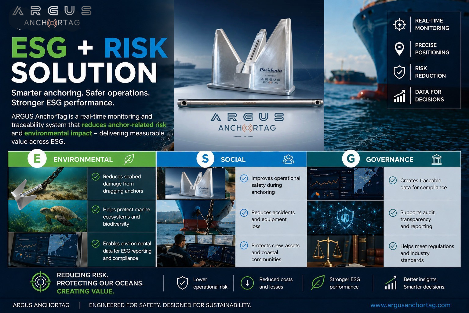
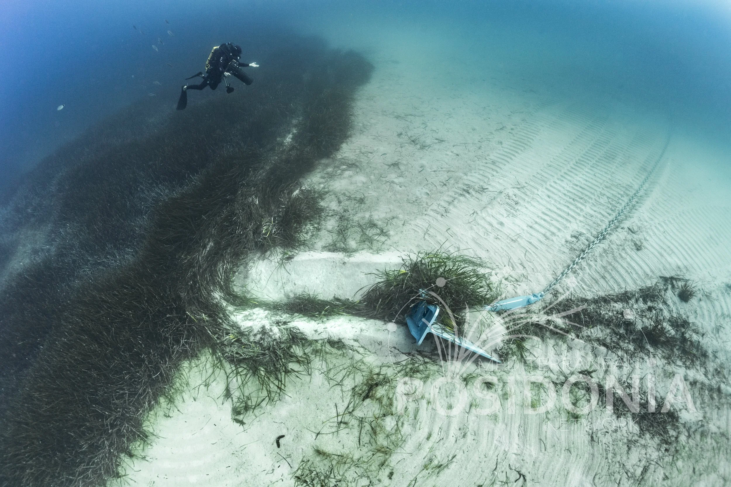
Predictive anchor monitoring technology that helps prevent anchor dragging before it occurs, reducing seabed damage and protecting sensitive Posidonia oceanica meadows. By providing real-time anchor status and early warning alerts, ARGUS supports responsible anchoring and sustainable boating practices. Supported by the Mediterranean Posidonia Network's objectives of improving monitoring, strengthening protection measures, and reducing anchoring impacts on seagrass habitats.